
TITUSVILLE, Penn.—Communities from Minnesota to Pennsylvania are facing a multi-day onslaught of snow during their 2025 Thanksgiving week, which is expected to cause hazardous disruptions to post-holiday traffic.
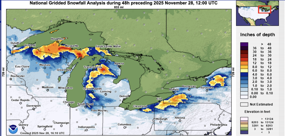
Beginning on Nov. 26, one of the region’s first snowstorms of the year came off the Great Lakes and delivered more than 12 inches of snow to several areas within the first 24 hours.
Marquette, in Michigan’s Upper Peninsula, was hit by the morning of Nov. 27 and celebrated most of Thanksgiving Day under a blizzard warning.
By the morning of Nov. 28, most of the Upper Peninsula was under a foot of snow, as well as 18 inches or more falling in and around Grayling, Michigan.
Northern Wisconsin was also hit hard.
The National Weather Service’s (NWS) Green Bay office reported more than 20 inches in Rest Lake and Land o’ Lakes, as well as 33 inches of snow in Gile, just outside Montreal, Wisconsin.
Further east, the service’s office in Buffalo, New York, told The Epoch Times it received several reports of more than 10 inches of snowfall coming off Lake Erie and Lake Ontario across its forecast area.
At least six to 12 inches of snow has fallen inland of Lake Erie from Linesville, Pennsylvania, through Corry, Pennsylvania, and Jamestown, New York, up to Warsaw, New York.
The lakeshore area from Cleveland through Erie and Buffalo received six inches of snow.
What is Lake Effect?
Lake effect snow is a weather phenomenon common to the Great Lakes Region in late fall and early winter.
It occurs when cold air, usually coming from Canada, passes over the lakes’ relatively warm and unfrozen waters.
Warm, moist air rises from the waterways and collides with the cold air, forming narrow bands of clouds that can produce up to two to three inches of snow an hour.
The National Weather Service stated its meteorologists consider several factors when forecasting lake effect snow, such as wind direction and the physical geography of the land.
States primarily affected by this weather are those closest to Lakes Superior, Michigan, Huron, Ontario, and Erie, which include New York, Michigan, Ohio, as well as parts of Pennsylvania, Wisconsin, and Illinois.
More Snow to Come
But this storm is not done.
Most of the Great Lakes region still sits under severe weather warnings.
The Weather Prediction Center said, “Snowfall rates of one to two inches will lead to storm total snowfall upwards of 1-2 feet with locally higher amounts possible, particularly downwind of Lake Superior across the northern Lower Peninsula of Michigan as well as downwind of Lakes Erie and Ontario.”
Titusville, in Pennsylvania, was expected to receive five more inches of snow with its lake effect warning remaining in place for Southern Erie and Crawford counties until Nov. 29.
Wind gusts as high as 35 mph were also predicted.
A winter storm watch remains in effect for portions of central and southwest Michigan through the morning of Nov. 29, including cities of Lansing, Grand Rapids, and Battle Creek, with an additional six to nine inches of snow predicted.
A large portion of Wisconsin is facing storms and will likely do so until early on Nov. 30. The heaviest snowfall is expected on the evening of Nov. 29.
“Heavy snow expected,” the National Weather Service warned.
“Total snow accumulations between 6 and 9 inches. Locally higher amounts near the Lake Michigan shoreline in excess of 10 inches are possible, particularly over Kewaunee and Manitowoc counties.”
Cities within that region include Green Bay, Oshkosh, Sturgeon Bay, Luxemburg, and Fish Creek.
Meanwhile, Chicago and its greater metropolitan area were expected to get six to eight inches of precipitation beginning late on Nov. 28.
Weather service offices across the Great Lakes region also warn of hazardous travel conditions.
They include snow and ice-covered roads and low visibility on stretches of Interstates 80, 90, 94, 75, and 69.
“Holiday travelers and hunters should be prepared for snow-covered roads and low visibility,” the National Weather Service’s Green Bay office warned.
“If you must travel, keep an extra flashlight, food, and water in your vehicle in case of an emergency. The latest road conditions for the state you are calling from can be obtained by calling 511.”
The Associated Press contributed to this report.
 Friends Read Free
Copy
Facebook
Tweet
Friends Read Free
Copy
Facebook
Tweet