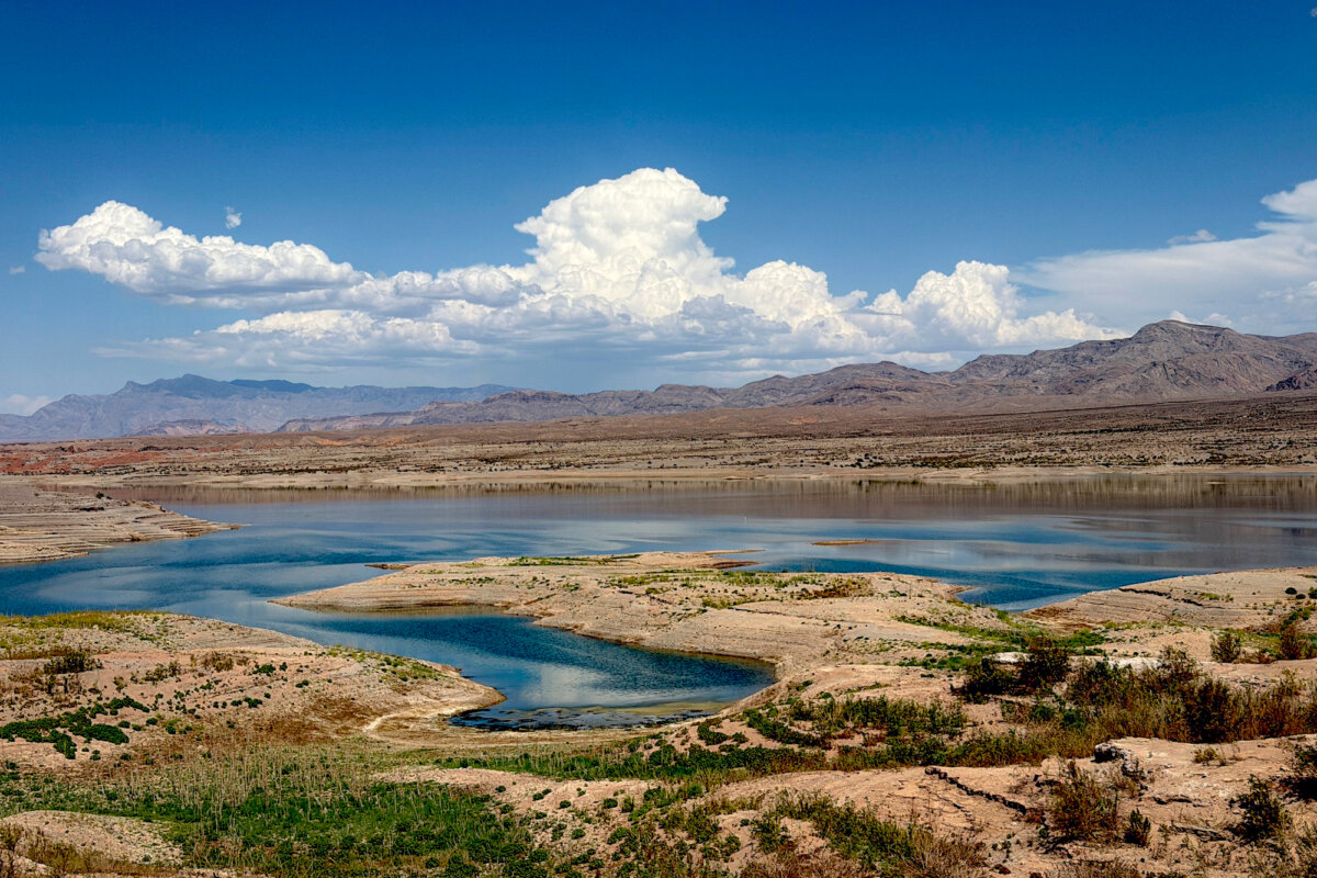

BOULDER CITY, Nev.—At Lake Mead’s Callville Bay Marina, exposed-rock bluffs now rise above the shoreline where the lake once covered the land.
A brown-and-white sign marks a vanished 2000 shoreline—and the beginning of a decades-long regional megadrought.
Farther downslope, the marina and boat slips come into view, but reaching them on foot requires a hike through 100-degree heat.
The drought has transformed the man-made lake into a shrunken version of itself, with no end in sight. The falling water level threatens supplies and hydroelectric power for millions and has forced some boat ramps to close.
“It’s getting pretty scary. You know, the water’s dropping to a level where they can’t keep up with marking the hazards,” a marina employee told The Epoch Times, requesting anonymity.
“It’s hard for people to launch their boats because the water level is dropping at such a pace. The maintenance to keep up the launch ramps is difficult.”
In some cases, shallow water has left boaters with broken propellers and scraped hulls after they’ve struck rocks and debris that were once deep underwater.
The employee pointed toward a location hundreds of feet away.
“Can you see the cement over there?”
That’s where the water once lapped against the shoreline, the employee said.
Now, green grass grows along the dry lake bottom.
“You can see the years and the levels where the water was. It just keeps going down and down and down,” the employee said.
“Look around. I mean, this is serious. Look how quiet it is.”
But Lake Mead is only part of the story. Its fate is tied to Lake Powell, its sister reservoir about 300 miles upstream, and ultimately to the Colorado River that supplies them both.
Warmer temperatures and declining snowpack have reduced the water feeding the river and, by extension, the lakes. All are critical sources of power for dams that provide hydroelectric power for customers across the Southwest.
Historic Drought
Olivia Conner, a land shuttle driver at Calville Marina, said she’s witnessed severe droughts before, but nothing like the regional drought of the past two decades.
“There has been a huge drop in the lake levels this year for sure. It’s about at the lowest point it’s ever been right now,” Conner told The Epoch Times.
Hydroelectric reservoirs have two critical thresholds. “Dead pool” marks the point at which water can no longer move downstream by gravity. “Power pool” is the minimum level needed for water to reach the intakes that feed the dams’ hydroelectric turbines.
Lake Mead is currently at 1,039 feet above mean sea level and 26 percent full, down from its 1,229-foot full pool, and 18 feet lower than in 2025. The reservoir is currently at 144 feet above dead pool and 89 feet above power pool.
When it reaches dead pool, it will be unable to power the Hoover Dam. The massive dam, built in 1931, supplies the power needs of nearly 8 million people.
Lake Powell, the nation’s second-largest reservoir behind Lake Mead, is just under 22 percent full, about 183 feet below its 3,700-foot full pool and roughly 29 feet lower than a year ago.
The reservoir supplies water to Glen Canyon Dam, which supplies electricity to roughly 5 million customers. At the current drought level, the reservoir sits 147 feet above dead pool and 27 feet above power pool.
Double Trouble
The Colorado River runs 1,400 miles from the Continental Divide in Colorado to the Gulf of California in Mexico.
Its basin spans 250,000 square miles and is a critical resource for the seven states it crosses, according to the Bureau of Reclamation, which oversees the reservoirs and dams at both lakes.
Arizona, California, Colorado, Nevada, New Mexico, Utah, and Wyoming depend on the river for water, hydropower, recreation, and natural habitat.
“Although agricultural uses depend on 70 percent of Colorado water, between 35 [million] and 40 million people rely on the same water for some, if not all, of their municipal needs,” the Bureau of Reclamation states.
Some of the river’s water also flows to Mexico under a 1944 treaty, the agency adds.
More than 5 million acres of farmland and 30 tribal nations draw water from the river and its tributaries.
Situated in the downstream, lower portion of the Colorado River basin, Lower Basin states are allocated 7.5 million acre-feet annually under the 1922 Colorado River Compact. California, with senior water rights, claims 4.4 million acre-feet; Arizona, 2.8 million; and Nevada, 300,000.
Evaporation accounted for 61 percent of the drought’s severity between 2020 and 2022, as shown in National Oceanic and Atmospheric Administration research. Less rainfall accounted for the remaining 39 percent.
Droughts can develop even when precipitation remains within a normal range, as higher temperatures and evaporation remove water from soils, the organization said.
Even modest warming can make droughts longer, broader, and more severe.
Reservoirs in the Upper Basin states are faring better. Wyoming’s Flaming Gorge is 71 percent full; western Colorado’s Crystal Creek Reservoir is at 89 percent; and the state’s Morrow Point reservoir is at 97 percent, the Central Arizona Project says.
New Guidelines
On Aug. 21, the Department of the Interior issued new operating guidelines for 2027–2028, requiring the Lower Basin states to reduce Colorado River water use by 1.25 million acre-feet annually.
That includes 760,000 acre-feet from Arizona, 440,000 from California, and 50,000 from Nevada. The states must also voluntarily conserve and store an additional 700,000 acre-feet over two years.
No mandatory restrictions are required for Upper Basin states—Colorado, New Mexico, Utah, and Wyoming—under the new guidelines.
The guidelines establish a 10-year framework for managing the Colorado River and protecting critical infrastructure at Glen Canyon and Hoover dams.
They also provide flexible tools and voluntary conservation measures to address the prolonged drought, the department said.
The Interior Department added that since January 2025, the Trump administration has invested more than $3 billion in water delivery, storage, distribution, treatment, and efficiency projects across the Colorado River Basin.
Arizona Gov. Katie Hobbs praised the plan.
“With this plan, we saved Arizona from forced federal cuts that would have crippled our economy and America’s national security,” Hobbs said in a statement.
However, she criticized what she described as unequal treatment of Lower and Upper Basin states.
“The federal decision also protects Upper Basin reservoirs at the expense of Lake Mead and falls short of providing the water that the Lower Basin is entitled to, all while the threat of unilateral federal cutbacks in future years remains,” she said.
Colorado Gov. Jared Polis said Upper Basin states were “encouraged” by guidelines that will “better reflect existing water supply, which must underpin any practicable plan going forward.”
“The water supply realities of the Basin cannot be ignored or papered over,” Polis said in a statement. “States in both the Upper and Lower divisions of the basin are feeling the pain of severe drought.
“This is a reality that all states, and the federal government, will need to address practically, which is why a seven-state agreement will provide the best outcome for all water users in the Colorado River Basin.”
Recreating Recreation
At Lake Powell in Page, Arizona—population 7,440—receding shorelines are affecting access to more than drinking water.
The main concern is infrastructure for launching and retrieving boats, said city public information officer Adam Geller.
Declining water levels have also hurt local revenues.
Since June 2025, the city’s sales tax revenue was down more than 11 percent and hotel tax revenue fell more than 22 percent, Geller said.
Short-term rental occupancy is down 10 percent. Hotel occupancy fell roughly 6 percent in July.
“We saw similar declines for May and June as well,” Geller told The Epoch Times.
The decline is largely tied to boating and multiday visits, he said.
Horseshoe Bend and nearby Antelope Canyon, the city’s two biggest attractions, are less affected by lake levels and continue to draw visitors.
Both, however, have seen some declines due to factors including slower international tourism and higher fuel costs.
The National Park Service manages lake ramps. It has funding for projects at Antelope Point, Bullfrog Marina, and other locations that will extend ramp access to cope with low water elevation.
“On our end, we’re working to promote tourism and improve the experience people have when they get here,” he said.
Plans include downtown beautification, new trails, digital passports to encourage longer stays, and promoting Page as the hub of the Grand Circle—the road trip loop that includes the Grand Canyon and several other national parks and monuments across the Southwest.
The city has also approved land sales for two new luxury resorts. Retail and restaurant developments are also planned, Geller said.
Going With the Flow
Geller said the city is planning around a “realistic possibility” that reduced lake access could continue and affect local businesses.
The Department of the Interior’s new operating guidelines set 3,510 feet as a protective target for the lake, with releases managed to defend that level, he said.
“Current federal projections still show the lake dipping below 3,510 in the coming water year, so we’re not overselling the near term. But having a defended long-term floor is real progress,” Geller said.
Protecting Page’s economy and quality of life will require “honest, realistic planning,” Geller added.
“That means telling people plainly what lake access looks like right now, continuing to build the kind of experience that keeps visitors here longer regardless of lake level, and staying engaged with the federal agencies who control the timeline for any of this to turn around,” he said.
Mikayla Daw, manager of Stix Liquor and Sporting Goods in Page, said Lake Powell’s declining level hasn’t yet been a major concern. There has still been plenty of water for sailing and fishing.
“But now it’s just getting lower and lower,” she told The Epoch Times. “It wasn’t busy this summer, it was just pretty much a little bit lower than what you would expect.
“As far as business, we’re doing pretty good. We’re keeping it steady.”
The falling water has also created new recreational opportunities, including hiking along newly exposed areas, she said.
On a recent August morning, Antelope Marina was still serving tourists with boat and Sea-Doo rentals, lake tours, and a restaurant.
“The lake is still there. There’s stuff to do on the lake,” Daw said. She believes higher gas and diesel prices have had more of a negative impact than dropping water levels.
“So the best thing to do is just kind of promote things and tell everybody the lake is still here.
“Everybody kind of thinks fall season is going to be an all-time low, but I’m keeping it positive.”
Lacee Nichols, a boat driver at Lake Powell Paddle Boards and Kayaks in Page, said the man-made lake appears to be at its lowest level since 1963, when it was formed.
“We’re not having to carry our kayaks up and down a very long hill now that it’s dropped so much,” Nichols told The Epoch Times.
“There have been quite a few more rocks and cliffs coming up out of the water, so it’s just making sure we pay attention.”
Despite the prolonged drought and lower water levels, life on the lake continues much as before, she said.
“You can still do about the same activities out here that you used to,” Nichols said. “Personally, I would love our water to come back. It keeps customers from worrying so much.”
At Lake Mead, Conner also stays positive. “The problem is just at the shorelines,” she said. “Once you get out there on Lake Mead, it’s still beautiful. There’s still tons of water, plenty of space to recreate.”
Conner is hoping that predictions of an increasingly strong El Niño later in 2026 will bring more rain—and much-needed relief.
“We are hoping for the best,” she said.
 Friends Read Free
Copy
Facebook
Tweet
Friends Read Free
Copy
Facebook
Tweet