
El Niño has arrived early, and it could shape up to be historically strong as it warms the tropical Pacific Ocean, possibly bringing with it some of the hottest weather in years, meteorologists announced June 11.
Forecasters with the National Weather Service (NWS) issued an El Niño advisory Thursday after announcing the warm climate pattern had developed a month before expected in the tropical Pacific.
AccuWeather’s long-range weather expert Paul Pastelok also reported on June 11 that El Niño had already started affecting ocean temperatures, a key indicator of the pattern’s arrival.
“The sea surface temperatures are quickly changing in the equatorial Pacific,” Pastelok wrote.
By early June, the water in the equatorial region had risen by at least 0.9 degrees Fahrenheit, reaching a threshold associated with El Niño conditions, according to AccuWeather.
Experts at AccuWeather say there is a 40 percent chance the climate pattern evolves into a “super El Niño” and say the climate pattern could reshape weather around the globe into 2027.
“Most El Niños begin in the fall, so this is developing much earlier and faster than expected,” AccuWeather Senior Meteorologist Chad Merrill said. “The weather patterns here early in the summer are also lining up to what is expected with an El Niño.”
To reach the level of “super El Niño,” water near the equator in the eastern Pacific needs to reach at least 3.6 degrees Fahrenheit above the long-term average, according to AccuWeather experts.
This year, the warmth was reported to be higher than in any year since 1982, according to AccuWeather experts.
Hotter weather could also be in store for the rest of the year if El Niño strengthens.
The stronger El Niño this year is expected to spike global temperatures, according to Senior Meteorologist Jonathan Erdman on the Weather Channel. Previous super El Niño events crushed previous global temperature records, including the most recent in 2015 and 2016, he said, making those years some of the warmest on record for the planet.
Only five “super El Niños” have been recorded, Erdman said. The rare patterns have also occurred in 1997, 1991, 1982, and 1972. Super El Niños may also have occurred in 1888 and 1877, Erdman said.
El Niño, the warm phase of the El Niño Southern Oscillation—a recurring climate cycle in the tropics–is expected to develop to a moderate or stronger level by the fall, according to the NWS.

Forecasters predict a 63 percent chance of ocean surface temperatures being 2 degrees Celsius higher than usual in the Niño-monitored region of the Pacific Ocean. If that happens, the National Oceanic and Atmospheric Administration (NOAA) will consider the event a “very strong” El Niño.
Last month, NOAA predicted the El Niño pattern would emerge in July and continue through the winter.
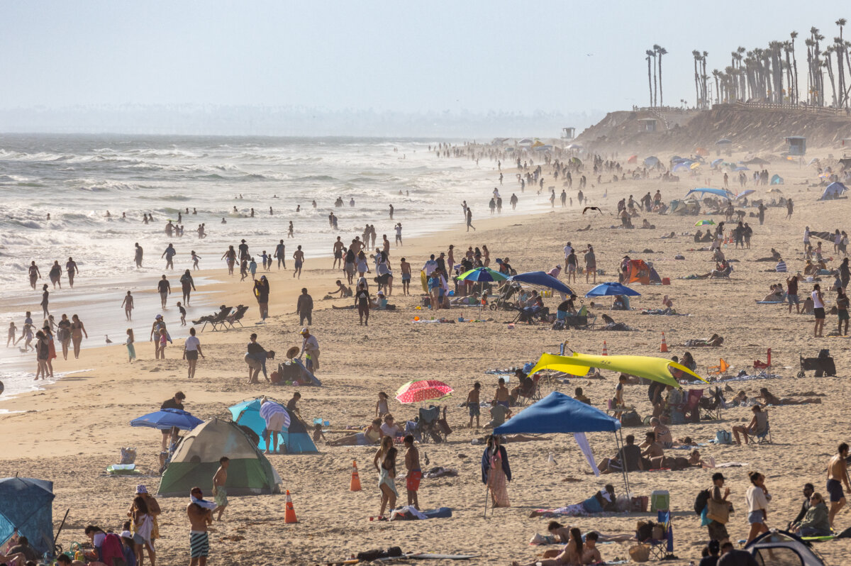
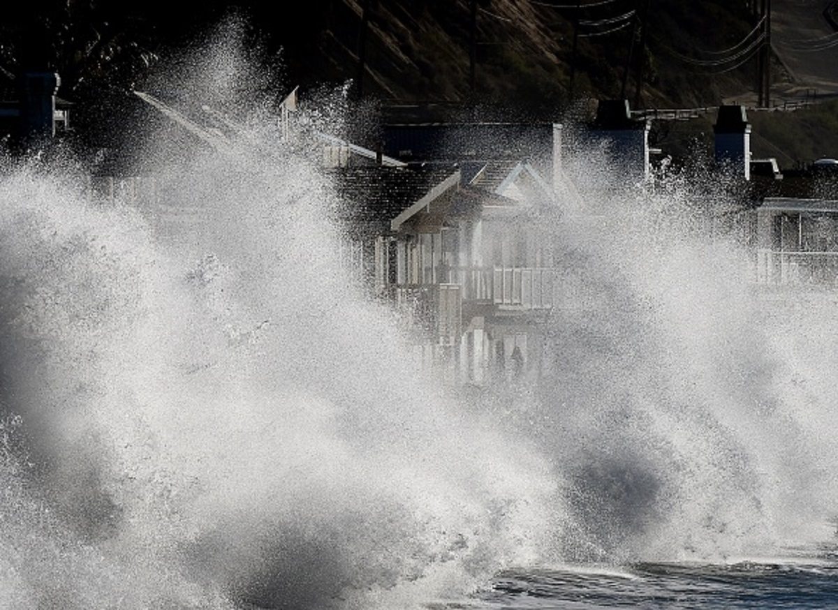
This year’s pattern could mean more high tide flooding, according to the weather service.
During an El Niño, the trade winds weaken across the tropical Pacific, triggering Kelvin waves that travel eastward along the equator and then up the west coast of the Americas, the weather service said.
As it travels, the waves warm the upper ocean and raise the ocean surface temperatures and sea levels for several months, or longer.
“Every El Niño is not the same; each one is unique with its own imprint on our weather,” Ken Graham, the director of NWS, said.
West Coast High Tides
The weather pattern moves the Pacific jet stream south of its neutral position, elevating sea levels along the West Coast of the United States, which can cause high tides and strong surf, which in turn can push much further inland than normal, according to NOAA.
The Atlantic coast can also be affected when the jet stream steers storms toward the mid-Atlantic, resulting in more storm surge events, NOAA stated. Higher amounts of rain can also occur along the Gulf Coast and the southeast coasts.
“It usually ends up being a double whammy,” NOAA oceanographer and high tide flooding expert William Sweet said.
Summer Weather Changes
Weather across regions of the United States could intensify as El Niño strengthens, according to weather experts.
Severe weather and tornadoes can increase in the central and eastern United States during the summer, while other regions can expect drier conditions, AccuWeather experts said.
“It will intensify drought in the Northwest and northern Rockies and lessen drought intensity and coverage in the Southwest,” Merrill added. “It won’t do anything to eliminate the long-term drought in the Southeast and mid-Atlantic until we get to late fall and early winter.”
El Niño could lower the total number of storms, but it is not expected to shut down the Atlantic hurricane season, according to AccuWeather lead hurricane expert Alex DaSilva.
AccuWeather’s Atlantic hurricane season 2026 forecast is calling for 11 to 16 named storms, four to seven hurricanes, two to four major hurricanes, and three to five direct-impact hurricanes in the United States.
Those numbers are in range with last year’s numbers.
The World Meteorological Organization warned the public that above-average temperatures were forecast nearly everywhere for June to August this year.
 Friends Read Free
Copy
Facebook
Tweet
Friends Read Free
Copy
Facebook
Tweet