
The eastern two-thirds of the United States will be hammered by a winter storm and freezing temperatures starting on Friday and lasting into Monday, threatening widespread travel disruptions and power outages due to ice.
The storm, which could impact more than 100 million people in the United States, is forecast to bring as many as 20 inches of snow in the Appalachians and West Virginia mountains, while many people living in the eastern part of the country could face dangerous slick or frozen roads and potential power outages from ice-laden trees and branches falling and snapping power lines, officials said.
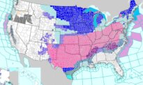
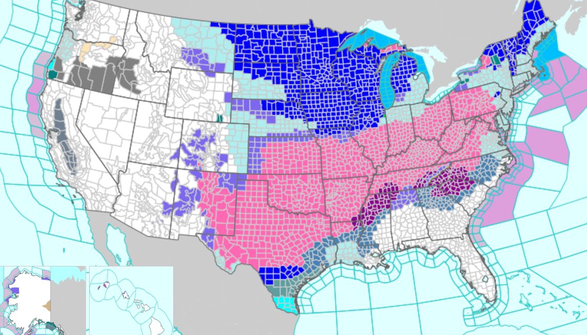
“A significant, long-duration winter storm will bring widespread heavy snow, sleet, and freezing rain from the Southern Rockies to New England through Monday,” the National Weather Service (NWS) warned on Friday.
“Widespread travel disruptions, prolonged power outages, and vast tree damage is likely. Frigid temperatures, gusty winds, and dangerous wind chills will expand from the north-central” across much of the East Coast, it added.
In a separate bulletin, it further advised of “catastrophic ice accumulation” expected from the Southern Plains region to the South.
The ice-causing “widespread freezing rain and sleet are expected across the Southern Plains, the Lower Mississippi Valley, the Tennessee Valley, and the Southeast,” the service said.
“The storm will cause significant to locally catastrophic ice accumulations with the potential for long-duration power outages, extensive tree damage, and extremely dangerous or impassable travel conditions.
“In the wake of the storm, communities from the Southern Plains to the Northeast will contend with bitterly cold temperatures and dangerously cold wind chills. This will cause prolonged hazardous travel and infrastructure impacts.”
Ice and snow could begin falling later Friday in Texas and Oklahoma. The storm was expected to move into the South with freezing rain and sleet, leaving behind a layer of ice thick enough to break tree branches and power poles.
Then it will move into the Northeast, dumping around a foot of snow from Washington, D.C., through New York and Boston, the National Weather Service also said. Boston declared a cold emergency through the weekend with wind chills predicted to dip well below zero.
New York City, Boston, Baltimore, and Washington, D.C., could receive 4 to 10 inches of heavy, wet snow starting on Saturday, forecasters with the NWS said, with temperatures in the low 20s Fahrenheit in Washington and a low of 7 degrees Fahrenheit in Boston.
A post on Thursday from the NWS suggested that as many as 160 million U.S. residents could be affected by the system and are currently under some form of winter weather advisory.
Over 160 million Americans are under winter hazards associated with the impending major winter storm. Disruptive snowfall is likely from the Southern Rockies to the Northeast, including dangerous ice from the ArkLaTex to the southern Mid-Atlantic. Here are the latest Key Messages pic.twitter.com/bmVIT5to7a
— NWS Weather Prediction Center (@NWSWPC) January 22, 2026
New York Gov. Kathy Hochul told her residents to expect the heaviest snow in years.
“We are heading into a very, very dangerous weather event,” Hochul said, pointing to the possibility of hypothermia and frostbite.
The Associated Press contributed to this report.
 Friends Read Free
Copy
Facebook
Tweet
Friends Read Free
Copy
Facebook
Tweet