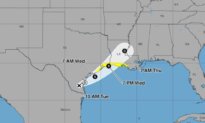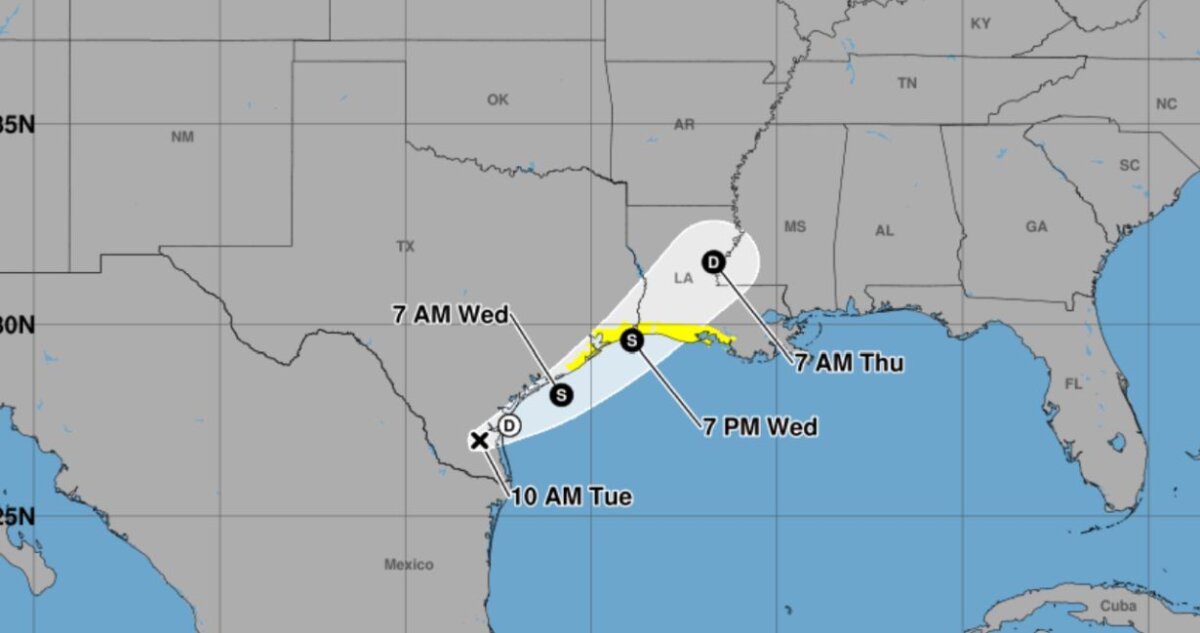

Tropical storm watches have been issued along areas of the Gulf Coast from Texas to Louisiana due to a potential tropical storm that may form in the Gulf of Mexico, according to an advisory from the National Weather Service (NWS) on Tuesday.
The watch was issued for the northwestern Gulf Coast, spanning an area from Sargent, Texas, to Morgan City, Louisiana. A watch means that tropical storm conditions are possible within the watch area within the next 24 to 36 hours, it said at around 10 a.m. ET on Tuesday.
The National Hurricane Center (NHC) said that possible Tropical Storm One “should move offshore the Texas coast tonight or early Wednesday, move roughly parallel to the upper Texas coast later on Wednesday and move back inland in extreme eastern Texas or southwestern Louisiana late Wednesday or early Thursday.”
No tropical storm has formed yet.
“The disturbance is forecast to gradually strengthen and could become a tropical storm early on Wednesday,” the hurricane center said. “Weakening is anticipated on Thursday after the system moves back on land.”
The system is expected to produce “very heavy rainfall” along with “dangerous flash flooding” in the watch area, according to the NHC.
If the system is categorized as a tropical storm, it will be called Arthur, which would be the first named storm of the 2026 Atlantic hurricane season that runs from June 1 to Nov. 30. The NHC gives the storm a 60 percent chance of becoming a tropical storm through the next 48 hours.
At the same time, around 10 million Americans on Tuesday are under flood advisories from Texas to Mississippi, according to the NWS.
The cities of Houston and New Orleans, as well as the suburbs around San Antonio, Texas, were also under flood advisories, meaning more than 10 million people are under some form of warning or watch on Tuesday, according to an Epoch Times review of NWS maps.
Heavy rainfall could lead to major flash flooding from Corpus Christi, Texas, to Houston, along with areas from Lafayette and Alexandria, Louisiana, as well as McComb, Mississippi, according to NWS maps.
Rainfall totals of 4 to 8 inches with isolated higher totals around 12 inches are expected from the tropical system around parts of the Texas coast and through much of Louisiana along with the central and southern portions of Mississippi and Alabama, the NHC said. The far western portion of the Florida Panhandle could also see significant rainfall, the agency said.
The NWS’s Storm Prediction Center separately forecast that tens of millions of Americans could see a “moderate risk of severe thunderstorms” on Wednesday, including areas around Chicago, Indianapolis, and Des Moines, Iowa.
 Friends Read Free
Copy
Facebook
Tweet
Friends Read Free
Copy
Facebook
Tweet